


Posted by Realtor David Olson 952.314.9446
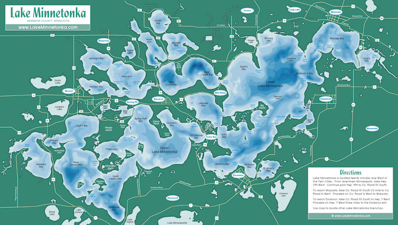
All the Bays in Lake Minnetonka
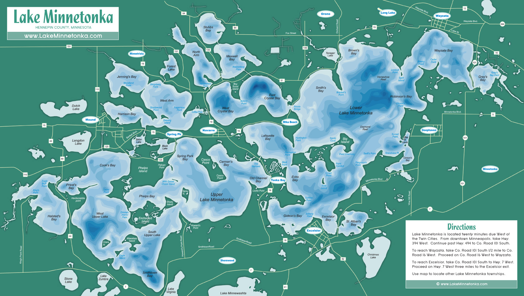
Lake Minnetonka is a massive lake that stretches across numerous communities. While it’s residents refer to it as a singular body of water, Lake Minnetonka is actually a collection of several smaller, kettle lakes that are adjoined to one another via straits and channels. It is this unique, sprawling layout that causes Lake Minnetonka to be so diverse in its lakeshore offerings and to have so many unique beaches, marinas, and bays. Below is an exhaustive list of all the bays in Lake Minnetonka:
Halsted’s Bay: Located on the most western end of Lake Minnetonka and within the city of Minnetrista, this bay was named after one of the first settlers in the area, Frank W. Halsted. Water flows into the bay from the Six Mile Creek to its west. The bay is also littered with private docks that belong to the local residents. Halsted Bay was one of the very last to experience residential development. This spot is currently a very popular spot in which to live, as the locals enjoy prime access to Lake Minnetonka
Priest’s Bay: Priest Bay is located on the western side of Upper Lake; between Cooks and Halstead Bays. The bay is within both of the cities of Mound and Minnetrista. The homes along the bay are very expensive, with stretching views of the beautiful lake. The bay was named after J.D. Priest, who had a farm nearby in the late 1800’s. The best homes are on Hardscrabble Point, which is on the south end.
Cook’s Bay: Cook’s Bay is within the city of Mound, and covers about 550 acres. Back in the day, this bay was home to many of the grandest hotels. Cook’s Bay provides a boat launch, and is home to Surfside park, one of the most popular parks and beaches in the area.
West Upper Lake: As the largest body of water in the western part of Lake Minnetonka, West Upper Lake is home to Lake Minnetonka Regional Park. The land surrounding this area is in Minnetrista, and the most outstanding homes are on both Hardscrabble and Cedar Point.
Smithtown Bay: As one of the most peaceful and alluring bays on Lake Minnetonka, and named after the Smith brothers (early settlers of the area), Smithtown Bay is where some of the most beautiful homes are located. The bay has easy access to the large lake, and because of its location, tends to have calmer waters on windier days.
Phelp’s Bay: Both the Phelp’s Bay and the nearby Phelps island were named after Carrington Phelps, who owned several hundred acres of land in the area. The homes near Phelp’s Bay enjoy a beautiful view of this magnificent bay, as each summer day it can be seen full of recreational life.
East Upper Lake: Another large body of water on Lake Minnetonka, the East Upper Lake is just south of Spring Park. Crescent beach is located on its shores and is a popular place to enjoy a summer day. The bay has several points that host more of the area’s expensive home.
Carman’s Bay: Located within the city of Orono, Carman’s Bay was named after John Carman, who was the first to settle in the area. The best spot to live along this bay is undoubtedly Casco Point, as the area provides highly coveted access and views of Lake Minnetonka.
Spring Park Bay: Spring Park Bay was named after the city on which its shores reside, Spring Park. It is a lovely spot that provides public boat access. This bay is also home to Lake Minnetonka’s main patrol station.
Black Lake: As one of the smallest parts of Lake Minnetonka, this lake is barely half a mile wide at best. It is a peaceful and quaint area to be. Access to the lake can be found across Black Lake Bridge, and it has a low-wake zone in order to allow for calmer waters.
Emerald Lake: On the west side of Lake Minnetonka, near Cook’s Bay and the city of Mound, Emerald Lake provides another calm and charming area for its residents to enjoy. Because of the minimum wake zone, this is a popular fishing spot on Lake Minnetonka.
Seton Lake: Seton Lake is a smaller body of water which derived its name from Elizabeth Seton. Located in the city of Mound, this lake serves as a channel between Cook’s Bay, Harrison’s Bay, and Spring Park Bay. This lake is also a minimum throttle zone, allowing for a calmer atmosphere.
Harrison’s Bay: Nathaniel Harrison, a boat builder and owner of a successful rice farm, was one of the very first residents in the area near Harrison’s Bay, hence its name. Shadywood Point, Centerview Beach and Lake Minnetonka Marina can all be found within the bay. Because of its location and amenities, this northwestern Lake Minnetonka bay is one of the busiest.
Jenning’s Bay: Jennings Bay was named after a printer from New York named Frederick Jennings. This bay is known for being one of the more active and social bays in Lake Minnetonka. With a maximum depth of twenty-six feet and an average depth of eleven feet, this bay is a prime location for boating and swimming.The total surface area of the bay is 290 acres. Woodland Point and Skogsberg Point both host the area’s most beautiful homes. The bay has shores that run along both the cities of Mound and Minnetrista.
West Arm Bay: Another extremely active and busy bay, West Arm Bay is named for its geographical location. This bay is also home to Rockvam Marina, which is a very successful and full-service family business that allows boat storage, slippings, and maintenance. The best real estate on the bay is on Fagerness Point and Shadywood Point. West Arm Bay has shoreline in the cities of Mound, Spring Park, and Orono.
Crystal Bay: Allen French was one of the early-day settlers in the northern part of Lake Minnetonka. He lived near Crystal Bay and highly appreciated and marveled at the water’s beauty. He was so enthralled with the scenic view, that he named the spot Crystal Bay for its crystal-like waters that reflected the skies above it. This bay provides outstanding views of the famous Lafayette Club and Noerenberg Gardens. Crystal Bay is the deepest part of Lake Minnetonka at 115 feet and the best homes are on Bohn’s Point. The bay has shoreline in both Orono and Minnetonka Beach.
North Arm Bay: Much like that of West Arm Bay, North Arm Bay received its name from its geographical location on Lake Minnetonka. This bay is unique in that it only has shoreline in one city, that being Orono. North Arm connects to Maxwell Bay to the east and Crystal Bay to the south. Many of the locals say that this is the best bay in which to go tubing or surfing.
Stubb’s Bay: As one of the remote and reclusive bays on Lake Minnetonka, Stubb’s Bay was named after the Stubb family, a family that had perhaps the most powerful farming business in the area. This bay is mainly residential and has shores along the city of Orono. Stubb’s Bay is in the northernmost part of Lake Minnetonka. This bay is another very popular spot to fish because it is large enough to host many fishing boats at once, but calm enough to enjoy the activity without interference from loud or active boaters.
Maxwell Bay: Like many of the early settlers in the mid 1850’s, the Maxwell family got word of Lake Minnetonka and the wonderful land that it offered. They built a cabin along the shore of what is know today as Maxwell Bay, and the body of water received its name from the family’s influence in the area. Maxwell Bay is in between Crystal and Stubb’s Bay. Noerenberg Memorial County Park, Wayzata Marina and North Shore Marina are the main areas of attraction as they offer residents and visitors access to the waters. The bay’s shores run along the city of Orono.
Lafayette Bay: The Lafayette bay is named after the famous luxury hotel that serviced thousands of tourists that visited the area in its glory days. The hotel was built by the famous James J. Hill in the 1890’s. This bay’s central location on Lake Minnetonka offers the ideal location to truly appreciate the wonder of this vast lake. Huntington Pointe, Recreation Point and West Point are the prime real estate areas on this popular bay. Lafayette Bay also serves as a backdrop to the famous Lafayette Club, which only adds to the wealth of amenities that the club’s members enjoy.
Smith’s Bay: Another highly active spot on Lake Minnetonka is Smith’s Bay. Northshore Marina, Arcola Bridge and the prominent Bracketts Point all call this bay home, as they offer the residents prime services and residential locations.
Brown’s Bay: Another early inhabitant to build a cabin on the shore of Lake Minnetonka was a man by the name of James Brown. He settled near this beautiful spot, which is known today as Brown’s Bay. This bay is situated along the eastern end of Lake Minnetonka, and has shores on both Wayzata and Orono. Lookout Point and Brackett’s Point are two of the prominent spots along this bay.
Wayzata Bay: The picturesque Wayzata Bay is the most scenic part of the city of Wayzata, the city from which it gets it’s name. The bay is constantly bustling with activity, and boats sail to and from their docks. Downtown Wayzata is close to the bay, and locals and visitors enjoy utilizing the popular Wayzata Beach. Along the bay are also several of the finest restaurants in which visitors can enjoy a family outing or a romantic date. The local Yacht Club, Shaver Park, and prime real estate areas of Cedar’s Pointe, Breezy Pointe, and Wick’s Point can all be found on this active and social bay.
Gray’s Bay: Gray’s Bay is Lake Minnetonka’s most easterly bay and is home to the headwaters of the Minnehaha Creek. This bay is unique from Lake Minnetonka’s other bays in that all boats must adhere to a closed throttle/minimum wake from 4pm on Fridays until after 12am on Monday morning. Minnetonka and Wayzata are two city lines that make up the shores of Gray’s Bay. Once called Lake Browning, this important bay was named after Amos Gray, one of the earliest founders of Lake Minnetonka in 1852. Public boat access is available on Gray’s Bay.
Robinson’s Bay: The shoreline on Robinson’s Bay is split between the city of Deephaven and the city of Woodland. This recognized bay on Lake Minnetonka is named after Alfred Robinson whose farm resided along the shoreline in the 1800’s. Robinson’s Bay lies on the southeast of Brown’s Bay, south of Wayzata Bay, and on the east side of the Lower Lake. Two points of interest of this bay includes Gibson’s Point and Robinson’s Bay Beach (located at 3344 Robinson’s Bay Road) which includes restrooms, a swimming dock, off-street parking and picnic tables. The lifeguard hours are from noon-6 p.m.
St. Louis Bay: The city of Deephaven encompasses this St. Louis Bay. Significant real estate in this area includes Sunset Point. This peaceful and calm body of water was named by Charles Gibson, who was a successful lawyer from the city of St. Louis. On the shoreline was the great Hotel St. Louis, built by Gibson. St. Louis Bay is located on the southeast shoreline of Lower Lake Minnetonka, just north of Carson’s Bay. Places of interest on this bay are Deephaven Beach which is the most popular beach in Deephaven. This is most likely because it provides on duty lifeguards and plenty of swimming areas in which to play. This bay also has two of the Lake Minnetonka Yacht Club’s islands; Lighthouse Island and Bug Island. This bay is an entirely closed throttle/minimum wake area.
Carson’s Bay: This peaceful bay is named after Elijah Carson who settled in the Deephaven area in the early 1850’s. Carson’s Bay is located southwest of St. Louis Bay on Lower Lake Minnetonka. This closed throttle and minimum wake bay is surrounded by the city of Deephaven. Grandview Point is a cape located in the Carson’s Bay whose elevation above sea level is 947.1 feet. Walden Beach is also in Carson’s Bay and is located at 19355 Walden Trail. Walden Beach has no lifeguards stationed at it, but it features amenities that include parking, picnic tables, restrooms, and beaches. Public access with city docks and mooring buoys are located on the south end of the Bay.
St. Alban’s Bay: St. Albans Bay is a scenic southern bay on Lower Lake Minnetonka which was named by Enos Day. A native of St. Albans, Vermont, Day moved to Excelsior in 1856. St. Alban’s Bay neighbors Excelsior Bay and is bordered by the cities of Excelsior and Greenwood. Bean’s Greenwood Marina is in Saint Alban’s Bay, and has been a family owned business for many years. It is also the only marina on Lake Minnetonka to provide covered slips. Tonka Bay’s Marina is also in this bay and provides services through three excellent marina locations which include Tonka Bay, Excelsior and the Shorewood Yacht Club. The marina holds docking for boats up to 70 feet. The marina also provides professional docking services in order to assist in taking off and anchoring.
Excelsior Bay: Excelsior Bay is located on the south shores of Lake Minnetonka. Three restaurants reside on its shoreline; Bayside Bar and Grill, Maynard’s Restaurant, and Haskell’s Restaurant. The cities of Excelsior and Greenwood connect to this famous bay. It is named after the town that surrounds its southern shoreline, “Excelsior”, which originates from Latin, meaning still higher. “Excelsior” was the motto of the early pioneers’ home state of New York. Excelsior Bay is a closed throttle and minimum wake bay that has public docking.
Gideon’s Bay: Gideon’s Bay is a bay of Lake Minnetonka bordered by the cities of Excelsior, Shorewood, and Tonka Bay. In 1853 Peter Gideon made a claim and put down roots in what is now known as Tonka Bay. Gideon, an apple farmer, created an apple that could survive the harsh Minnesota climate. He called it “The Wealthy” after his wife. Gideon’s Bay still bears his name today. Gideon’s Bay is next to Old Orchard Park which is located along County Road 19 (Manitou Road) next to the Tonka Bay City Hall (4901 Manitou Road). Grills, picnic tables, swings, and a fishing pier are available for all to enjoy at Old Orchard Park. Dock spaces are available for boat rental, but there is usually a several year waiting list. Also available for rental are boat slides and canoe racks.
Echo Bay: A bay of Lake Minnetonka bordered by the cities of Tonka Bay and Orono, Echo Bay is known for fishing. Word on the street is that fishing in Echo Bay is exceptional. Depending on weather and barometric pressure, the fishing can be best early in the morning between 4-6a.m.
South Lower Lake: South Lower Lake is north of Excelsior Bay and is separated from Lower Lake North by Big Island. The three cities that surround this bay are Deephaven, Greenwood and Orono. Ferguson Point and Gales Island are popular in this bay and are recognized for their prime real estate. This bay also contains Big Island Nature Park which is located on 56 acres at the east end of Lake Minnetonka’s Big Island. It’s one of the newest additions to the City of Orono park system. The property is well known as the home of the former Big Island Veteran’s Camp, and has a long history of recreational use dating to the early 1900’s. Through mutual collaboration between the City of Orono, the Minnehaha Creek Watershed District and other partners, Big Island Nature Park is intended to preserve the unique natural, physical, and cultural resources of the site while offering the Lake Minnetonka community and it’s visitors a variety of passive recreational and educational opportunities. Another group of interest on this bay is the Minnetonka Power Squadron Boat Club, whose purpose is to preserve the safety and beauty of boating on Lake Minnetonka.
North Lower Lake: The three cities that have lakeshore on the North Lower Lake are Orono, Greenwood, and Deephaven. Housing areas to pay attention to on Lower Lake North include Gibson’s point, Sunset Point and Swift’s Point. Being situated on the northeast of Big Island, in the heart of Lower Lake Minnetonka, this bay was the final resting place for three of Lake Minnetonka’s historical streetcar steamboats. Back in the day, The Como, the White Bear, and the Hopkins were all intentionally sunk in the lake. The Minnehaha was the only steamboat salvaged from this body of water, and restored to full operation. Nowadays during the warmer months, the Minnehaha provides passengers with a taste of what Lake Minnetonka living was like during the early 1900’s. The east side of the bay features Gale Island and the west side of the bay has Ferguson Point.
Forest Lake: Forest Lake is a small bay with an extra long channel as the only way in or out of the bay. It is usually fairly empty and has exceptional riding conditions. Forest Lake’s round shape and tall tree line offer full protection from the wind, providing very smooth water at almost any time of day. This bay is a local favorite and is located on the northwest side of Lake Minnetonka, off of the West Arm. As it’s name implies, it was named after it’s heavily wooded shoreline. In the mid 1800’s this bay was not connected to Lake Minnetonka. It was dredged to West Arm when it became a part of the lake. Due to the height of the North Shore Drive Bridge, boat access to the bay can be very limiting.
Libb’s Lake: Libb’s Lake is located on the eastern side of Lake Minnetonka. This bay was unattached from Lake Minnetonka’s Gray’s Bay until a channel was dredged in the 1800’s. Just like with Forest Lake, boat access can be limited because of the canal and height of the bridge on Gray’s Bay Blvd that runs over the channel. Libb’s Lake Beach Park is located here and is a special use area that services the local neighborhood and the larger surrounding community. The beach is located on Park Lane off of Lake Shore Drive in Ward 3. Providing beach amenities is the primary focus of Libb’s Lake, which is connected by channel to Lake Minnetonka. Libbs Lake is an entirely closed throttle and minimum wake area, and it is in the City of Minnetonka.
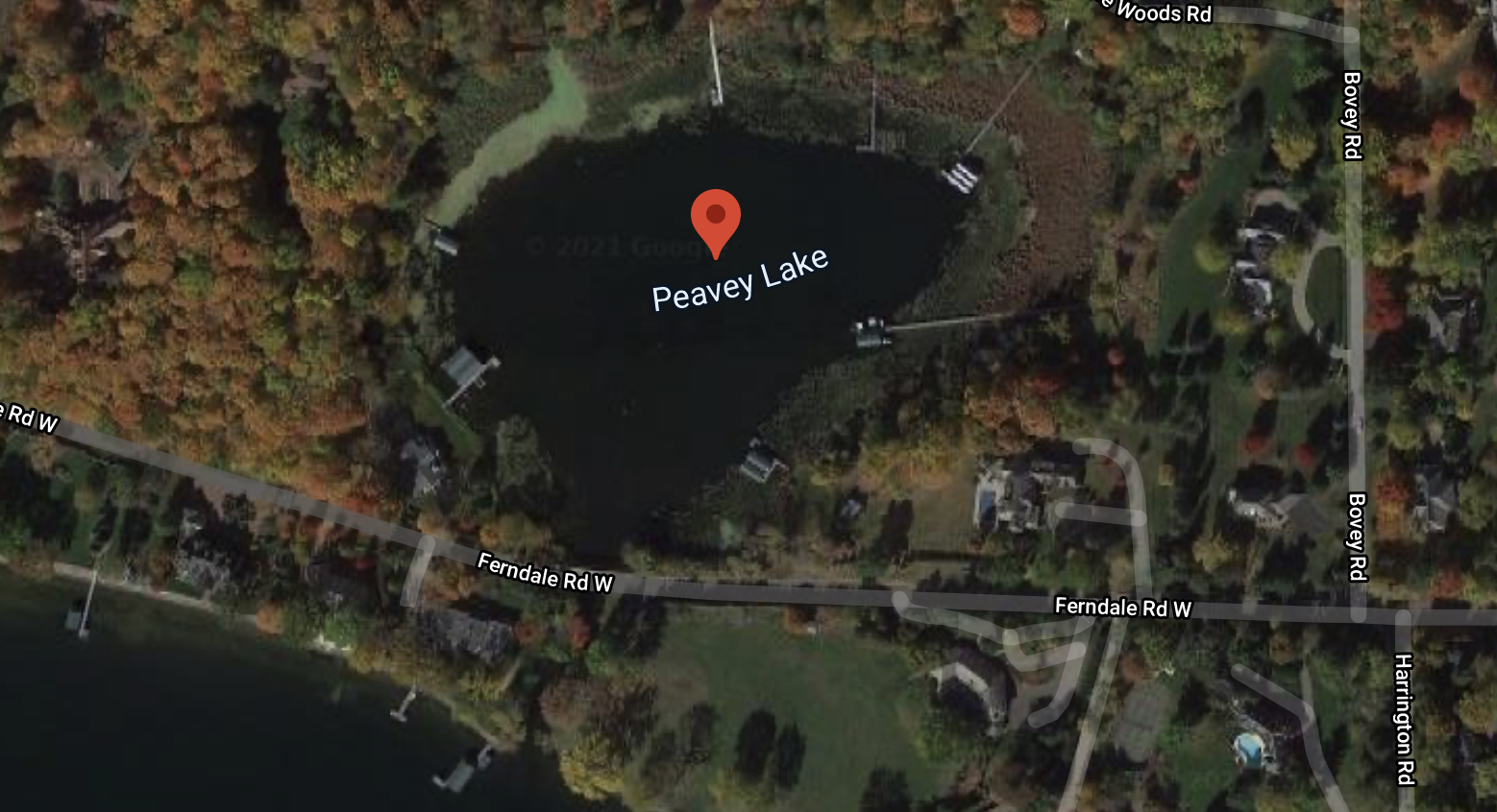 Peavy Lake: Peavy Lake is a bay named after Frank H. Peavey, an entrepreneur in farming in the late 1800’s, and was part of the Highcroft Estate. Peavy Lake was not originally part of Lake Minnetonka, but a channel was dredged that now connects it to Brown’s Bay. Boat traffic is limited due to the canal’s width and the height of the Ferndale Road Bridge, which runs over the canal. Peavy Lake is in the city of Wayzata and is a closed throttle, minimum wake body of water. This bay is about 9 acres in size and it’s deepest point is around 63 feet with around a half mile of shoreline. Anglers can expect to catch a variety of fish in this bay including Black Bullhead, Bluegill, Northern Pike, Yellow Bullhead, and Pumpkinseed. There is no boat ramp for public access. Average home price on this bay is around $2.7 million with an average price of $275 a sqft foot. A water test report for this specific bay can be viewed here. Invasive aquatic species in this bay include Eurasian watermilfoil and zebra mussels.
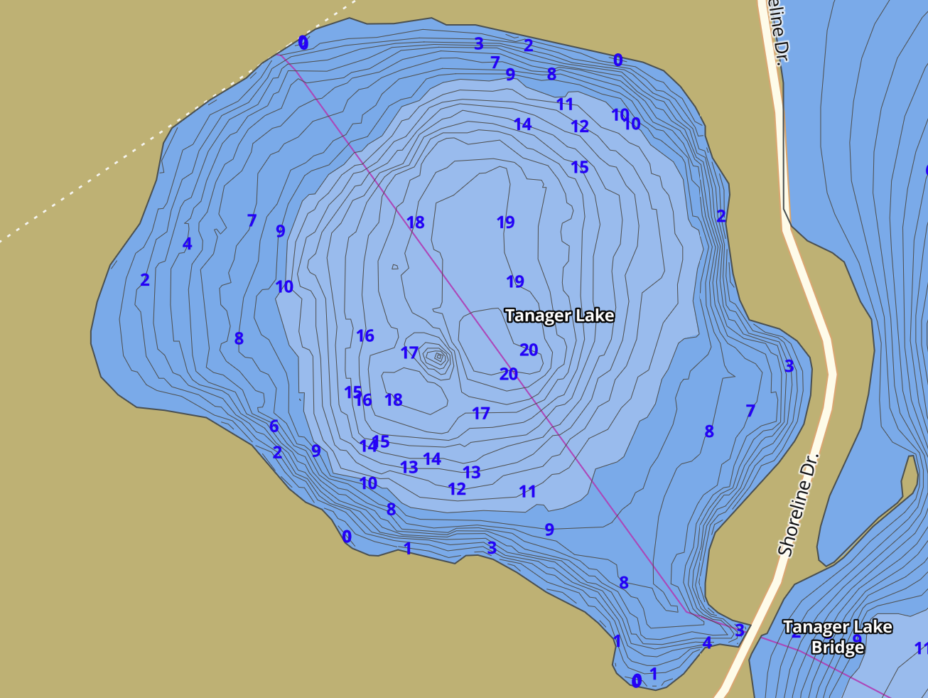
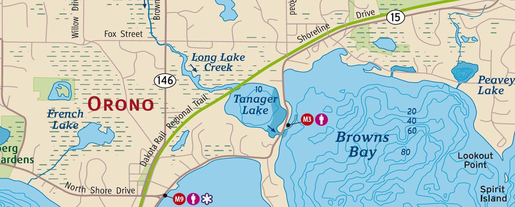 Tanager Lake: Tanager Lake is 54 acres of water (surface area), around 20 feet at its deepest point (average depth around 5 feet), and has about 1.2 miles of shoreline located west of Browns Bay in Orono Minnesota (in Hennepin County). It does NOT have a public ramp access and is considered a mostly isolated bay of Lake Minnetonka. Dakota Regional Trail has a beautiful section overlooking the North part of this bay. Years ago it was called ‘Mud Lake’ before it was connected to Lake Minnetonka. Currently it is connected to Minnetonka by a navigable channel, but it is one of several of Minnetonka’s “bays” which was at one point a separate lake. It had it’s channel widened in order to accommodate boats. It is located within the city of Orono and has less than ten residential lakefront homes on the bay. From a fishing stand point it is know for Black Bullhead, Bluegill, Brown Bullhead, Largemouth Bass, Muskie, Northern Pike, Walleye, White Crappie, Yellow Bullhead, Yellow Perch, and Pumpkinseed. It is also the bay where North Shore Marina is located. Average prices on this bay are around $2.5 million with the average price per square foot being around $342.00. Home on this bay are apart of Orono School district. Average residency for home owners on this bay is around 23 years. There are three aquatic invasive species know to reside in this bay. Eurasian watermilfoil, Zebra Mussels, and Flowering Rush. Here is a detailed report from this last decade about the water quality for this bay.
If you like to sell or buy a home on or around Lake Minnetonka or have any questions about the bays, marinas, and cities surrounding it, please feel free to contact realtor David Olson. He is a realtor, broker, and licensed general contractor specializing in luxury lake homes specifically on Lake Minnetonka and the surrounding areas. With over a billion in gross sales, 15 years of experience, and many hours on the lake, David can provide you expert insights about any home virtually, on the water, or by physically walking through any available homes for sale on the bays of Lake Minnetonka. 952.314.9446, [email protected], or visit www.DavidOlsonRealEstate.com

© Copyright 2021, www.TwinCitiesPropertyFinder.com All Rights Reserved.
Lake Minnetonka: The Marinas
City of Medicine Lake: Schools and District 284
Related City Articles